Yesterday, realtor Eileen Bermingham posted an article about the geographic subregions that exist in Bernal Heights:
Bernal Heights has many distinct areas within its neighborhood. From the hip enclave of Precita Park to the winding streets on the East Slope, the price of real estate literally varies depending upon which part of Bernal you’re in. So it’s important to lean heavily on sales in your particular part of the neighborhood when you’re accurately trying to determine property values in Bernal.
To help buyers and sellers with that task, I’ve deconstructed Bernal Heights into seven unofficial microhoods, complete with their respective price averages and low/high prices, as well as recent sales volume.
In this way, we are introduced to the comparative charms (and average home prices) of such areas as “The North West Slope,” and “Precita Park,” and “South of Cortland.” Unfortunately, it made us feel so… commodified. Ew.
That said, the idea that Bernal Heights consists of several distinct microhoods actually makes a lot of sense. After all, Bernal is a neighborhood defined by its topography — Remember, our last name is “Heights!” — so there’s an intuitive logic to the notion that different parts of the hill have very different subcultures and identities. Yet we are far more than our cost per-square-foot; we are a federation of nooks and crannies shaped by timeless geological features, historical quirks, and neighborly idiosyncrasies.
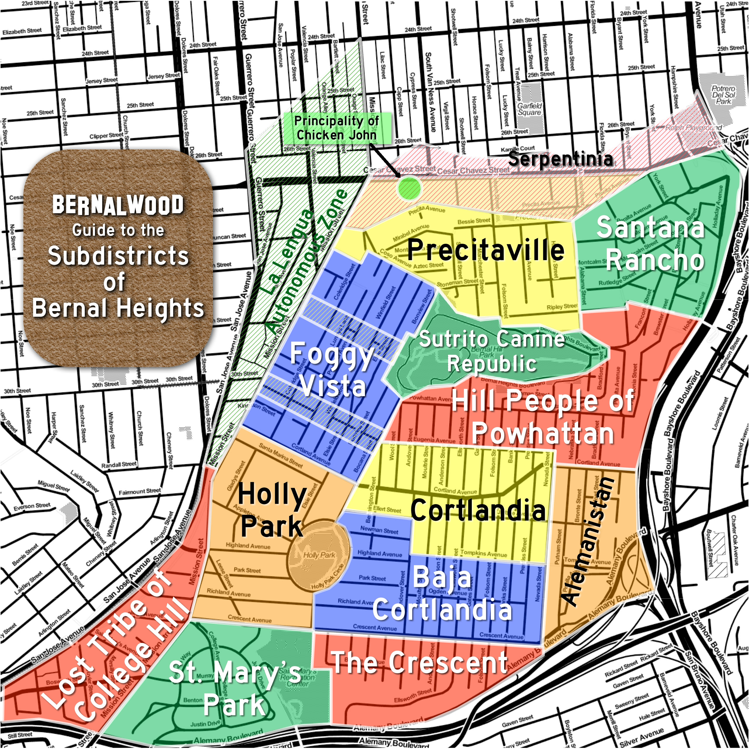
So please allow us to propose this homegrown draft guide to the Subdistricts of Bernal Heights, produced in collaboration with Burrito Justice, chief spokesblogger for the La Lenguan separatists. To wit, and roughly clockwise from the map shown above:
Precitaville – With the Mission as a front yard, Precita Park as the living room, and Bernal Hill as a backyard playground, Precitaville is perhaps the most cosmopolitan part of Bernal Heights. Perhaps.
Santana Rancho – Carlos Santana used to live here; Janis Joplin used to party here. The steep slopes and meandering streets of Bernal’s northeast corner have made it a secret haven for generations of local artists, musicians, and eccentrics.
The Sutrito Canine Republic – Located atop Bernal Hill in a public park, The Sutrito Canine Republic is patrolled by packs of very happy dogs who frolic off-leash and worship the microwave antenna array mounted atop Sutrito Tower.
The Hill People of Powhattan – With their homes clustered around Powhattan Avenue in the high-altitude reaches of Bernal Hill’s southeastern quarter, the Hill People of Powhattan are easy to recognize: Just look for their massive, hill-toned calves and slightly elevated demeanor.
Alemanistan – Dry, rocky, and sun-baked, Alemanistan retains a wild, untamed feel. Perched in the shadow of the Spaghetti Bowl, at the crossroads of two major highways, this is Bernal’s frontier borderland.
Cortlandia – The heart of Bernal’s historic commercial district has now become the ideal setting for a contemporary situation comedy about bourgoise-bohemian urban culture in the early years of the 21st century. Which is funny, except that it’s also rather lovely, and we are very lucky to have it. The residents of Cortlandia are justifiably quite proud of this.
Baja Cortlandia – Perhched just south and slightly below Cortland Avenue, Baja Cortlandia is scrappy place of haphazard hills, multigenerational residents, and intense, superhyperlocal pride.
The Crescent – This area of Bernal Heights is anchored by both Crescent Street and the Islamic Center and Mosque on the corner of Andover. So many Crescents.
St. Mary’s Park – Developed during the 1920s on the site of the former St Mary’s College campus, this self-contained, bell-shaped enclave feels like a little slice of the Sunset District, right in our own corner of Bernal Heights.
Lost Tribe of College Hill – Separated from the Bernal heartland by Mission Street, yet isolated by freeways from Glen Park, College Hill’s de facto independence is symbolized by a recent redistricting that saw the area transferred to Supervisor Scott Wiener’s District 8.
Holly Park – This ancient district of Bernal Heights is home to one of San Francisco’s oldest parks and a covered reservoir that has long been the setting for much local scandal and drama.
Foggy Vista – Rising above Mission Street on Bernal’s west slope, the groovy people who live here enjoy a commanding view of Nature’s own lava lamp: the massive banks of fog that cascade over Twin Peaks. Residents eagerly await construction of the Esmeralda Funicular to facilitate transit to and from the bustling Mission Street corridor.
La Lengua Autonomous Zone – This territory has been an integral part of the Dominion of Bernalwood since the 19th century, but today the uppity people of La Lengua enjoy limited autonomy under the terms of the 2010 Proclamation to the Vassals of La Lengua.
The Principality of Chicken John – Though located within the territorial boundaries of Bernal Heights, Chicken John’s warehouse residential complex and bus depot on Cesar Chavez functions as a world unto itself. Operating under its own sovereign codes, aesthetics, and social norms, and with it’s own 4.5 star rating on Yelp, The Principality of Chicken John is, in effect, Bernal’s version of the Vatican.
Serpentinia – Named after a long-gone street that used to mirror Precita on the northern side of Army/Cesar Chavez, Serpentinia is today defined by the major thoroughfare that now slices through its center. After decades of indifference and neglect, recent infrastructure upgrades on Chavez may bring new cultural vitality to this region.
So there you have it. Neighborly comments, suggestions, rants, and proposed revisions are most welcome, with an eye toward future iteration of this map.
REVISION NOTE: March 20: Based on comments provided by Bernal neighbors, the former “Outer Cortlandia” was renamed “Baja Bernal,” and then renamed again to “Baja Cortlandia.” The map has also been updated to include this change.

OK, I think we’ve reached new depths of micr-hood navel gazing with this one… In fact I think this has now officially “Jumped the Park” (Holly Park, Bernal Heights Park, Precita Park, …what/whichever, w/apologies to The Fonz)
Wait, is it Santana Rancho (map), or Santana Vista (text)? How about Rancho Santana Vista?
The map is canonical; the text is now fixed. Thanks!
Meant to say the first time: amazing work! And, Santana Rancho is the one place I can see from where I live in Potrero, so I’ll put the name to good use.
I don’t know about real estate prices, but splitting Holly Park into two different micro hoods is a mistake. Living on the park is a defining commonality among us, much more than whether we live on the south, west, east or north side of it.
That is correct, Joyce. I suspect They are trying to divide us, mistakenly thinking this will reduce our power.
Excellent point! Thank you. Feedback and comment is much appreciated, with an eye toward near-future revision of the map.
So glad that I’m in Cortlandia proper or I might request a vote on redistricting,
Vote, schmote! A few people from the College Hill Neighborhood Association were able to get redistricted without including any neighbors in their activity and you can, too! Send in an email to the ReDraw task force and call yourself the president of your made up association. As CHNA proved, you don’t even have to live in the neighborhood for more than a minute to redraw district lines.
At least we got out of District 9!
Might pay to consider terrain as well as streets when assigning borders. Those of us that live along Jarboe can walk quite easily to Cortland’s commercial strip (as Jarboe more or less follows the ridge line), even if we’re pretty far to the east. I’d be interested in an alternative map where microhoods are bounded strictly by elevation contours.
Living on the border between Cortlandia and Alamanistan, I am tempted to concur. Jarboe is indeed the link that binds eastern Alamanistan to Cortlandia. However, Alamanistan cannot really be Alamanistan without Putnam St, which is the true link to the Farmer’s Market. So the northern Alamanistanians will likely live forever with a bit of Cortlandia envy.
Ah, forgive me, of course, the proper spellings are Alemanistan and its people are the Alemanistanians.
Sigh. Living with envy is difficult, but I reckon I shall content myself with the fact I can walk to Lowe’s in 5 minutes.
Sorry Todd—one correction—what you have as “Outer Cortlandia” is actually officially known by residents as “Baja Bernal”…
I like!
Glad you do—it’s true! 🙂
Sharon, the map and text have been updated to reflect this change. Thank you!
Oh whew! Now we can use your map for actual navigation.
Bernal del Sur?
haha—no really—we already call it Baja Bernal!
No, no, no…. IMHO it really should be SOCO – South of Cortland… Just like SOMA is the cooler part the city South of Market, we’re the cooler part of Bernal south of Cortland.
/me runs….
Hi David. You’ll have lobbying to do if you want it to change from the currently used Baja Bernal to SOCO…:)
David, i have to agree with you. How can it be baja bernal? we arent below Bernal (we are below cortland) and we arent event the lowest part of bernal. its a poor name. I generally say Below Cortland or down from Cortland when people ask where i live
Baja Cortlandia?
Baja Cortlandia? its better than baja bernal, maybe i’ll say b.c. and if someone asks i’d say below cortland
APPROVED
Portola Norte? no me gusta!
keepin it real (sometimes, too real) South of Crescent (aka Crescent Fresh) in what we call Bernal Depths!
Ooh. That’s a good name. I LOVE learning the names that the natives of each microhood use self-referentially. So fun.
I definitely stole it from someone. iirc, I know the illustrious Vicky Walker is down with the name.
And Crescent Fresh? Well.. http://www.youtube.com/watch?v=dasab33h1nQ
Here at the end of Moultrie, we too find the ‘portola norte’ moniker a bit confusing and inexact. We go by The Crescent; anchored by the San Francisco Islamic Center and Mosque and their own spiritual crescent at Andover and Crescent. It would be weird to me to refer to a neighborhood as ‘norte’ since it lies the southern part of bernal. And I think if I look across the freeway I’m actually staring at University Mound and the bible school on the hill. Love the map, lots of fun, but that norte nonsense has been sticking in my craw since I saw it on the burrito network.
Great thoughts. Yes, that name is definitely a candidate for reconsideration. Another reader suggested “Bernal Basin”
The Crescent seems apt.
Agreed. Also on Moultrie. Portola Norte??? We aren’t Portola. I like The Crescent or even just lumped with SoCo. Bernal Basin has a ring too.
I am not so sure about Foggy Vista. Foggy View, maybe? The view is but one aspect of our local identity.
FREEDOM FOR EUGENIANA
La Lengua is not, had never been, and shall never be a part of Bernal Heights. You want to call it “Bernal Flats” or “Bernal Lowlands” or something? Sure. But to be Bernal Heights, you have to be on the hill.
plus one for “bernal flats”!
It IS Bernal Flats. Has been for a long time.
Well, no, it’s La Lengua, but you can use “Bernal Flats” as a nickname, if you want.
Wait! How could half of Precita Park be in “Serpentinia” instead of in “Precitaville”? And I live on Precita Ave., exactly one block from the park, but I’m in “Santa Rancho”? There’s some serious gerrymandering going on here…
Kind of like those contested bits of the Himalayas that India and China argue over. It is so sad to see Bernalians fighting amongst themselves.
Priceless in every way. Great write-up.
For those of us on the Western North Slope, a bit too far from Precita Park to be part of “Precitaville”, and with street names like Montezuma and Aztec, I propose the micro-micro-microhood of “Alta Mexico”.
For max trendiness, I suggest CoSto Ridge (as in Coso/Stoneman).
+1
What’s going on with Chicken John’s building? I saw lots of work being done inside recently and now there’s sign above the door. I can’t read what it says as it’s dark when I drive by there. Is it becoming a bar or restaurant?
As long as residents of Serpentinia in no way need to be associated with, or endorsers of, Chicken John, then I am supportive of this map. I would hate to have to move
Ditto.
What’s truly wild and untamed in “Alemanistan” are the nearby streets on the weekends, when the world descends onto the Farmer’s Market. Chaos reigns as drivers try to figure out who has the right of way on the narrow streets leading to the market, and illegal and unsafe parking becomes the norm. Yee-haw!
As a Fog View I could not agree more about the funicular. If they can do it in Valparaiso why not here
+1 for SURE!!!
How about “Niebla Vista” en vez de Foggy Vista. NEE-ebb-la Vee-sta has a lovely ring to it.
As a Niebla Vista resident, I second this. Usage begins… now.
I’ll leave it up to residents of the respective zones, but I’ll second (or tenth) killing the Chicken John reference. No personal offense intended, but he isn’t exactly Emperor Norton.
Liking the Niebla Vista…Thanks.
As for Chicken John… from a cartographic standpoint, the point is simply that he occupies a world unto himself.
I’ve been calling my Precita hood ‘Bernal Flats’ for eight years… still hoping it’ll catch on!
BREAKING NEWS- Bernal Heights Real-estate prices just jumped 20% after the release of this list!
i would just like to say how much i LOVE and appreciate this blog, and the HUGE effort that goes into making it creative, fun and reason for us to have pride in our incredibly special neighborhood (and now, microhoods, of course). love all of the names but as a resident of the ‘foggy vista,’ think we need to keep on working on that one. in the meantime, THANK YOU and keep up the amazing work (to you as well, burritojustice)!
I want a copy of this map — where to get??
We are working on that! Stay tuned…
Looking forward to this!
Lynn – i second that awesome endorsement of our gracious, hilarious, hardworking Bernalwood and Burrito Justice hosts. You guys rock! You brighten my day and feed my mind. Community and neighborhoods are such an interesting layered construct.
I stand united with my mini-micro-neighbors The Nebraska Street Regulars.
Oh wait, that makes us sound like were all two and half feet high. Well, you get the idea…
You can insist on La Lengua all you want but the residents of Tiffany Ave and surrounding areas will NEVER adopt this moniker. If we must call us (the denizens of this area) anything at all, it will be BernMissNoe (or BurnMissNoe). Please refrain from using La Lengua, which in certain Spanish-speaking countries can be vulgar.
Bernal Flats! (or “intermission” as google maps calls it)
What are you talking about? La Lengua is La Lengua.
Any resident of St. Mary’s Park knows it is called St. Mary’s Park, not just St. Mary’s. And…where in the flatlands of the Sunset can you see a whole neighborhood of detached houses with generous, landscaped front yards along streets that lazily wind and slope and curve, and whose streets have no telephone poles and power lines marring the elegance? Not to mention the wide grassy islands and tasteful traffic circles, which are maintained by us residents, not the city.
And, we have deep roots in Old San Francisco. On the same day a Sacramento newspaper reported on the laying of the cornerstone for St. Mary’s college, in 1851, the article above it told of a recent, bloody Indian massacre perpetrated on a wagon train coming into California.
A slice of the Sunset district? In a tipsy pig’s eye.
You win! Map will be modified to reflect this change. Thanks and thanks for the awesome perspective.
+1
“Tasteful traffic circles” makes my day.
Reblogged this on SF Luxury Living and commented:
The neighborhood breakdown on Bernal Heights and the micro neighborhoods that have a personality of their own.
Great job on the map, much more fun than mine!
Thanks Eileen! This has been in the works for a while; your piece gave me the kick I needed to finish it. Now, won’t you PLEASE begin guiding your clients around Bernal using the official nomenclature? 😉
I’d like to revive the Peralta Heights moniker for the East slope, roughly Alabama to Holladay, Precita to Esmeralda or maybe Mayflower. But I do like Rancho Santana, too.
Peralta Heights is the original name for that section back when there was another hill top (later chopped to fill in Bayshore marsh)
The Gillibus considers itself a mobile Temporary Autonomous Zone (TAZ) representing Bernal. If Todd were onboard, it would be like Air Force One or something.
Bernal One!
Natives don’t pay attention to this nonsense about Microhoods. I live in the Richmond. That’s it. This microhood stuff is all techy hipster new transplant BS. When I was growing up Bernal was a working class hood that no one ever went to.
That’s cool! So do you still speak Ohlone?
+1
Microhood names are old as dirt, you just need a defining feature i.e. Cathedral Hill.
Wait/ What? Precitaville doesn’t include all of Precita park and the like named cafe? That doesn’t make sense. Meh! Not to mention some of the most choice views in SF. I’m opting for Precita Heights.
Portola Norte? Hmm. Seems kinda mean-spirited to associate us kindly Portolans with your own housing projects and liquor stores.
That being said… beware!, our pre-gentrification ethos includes enormous pre-gentrified water balloon cannons aimed at targets all over Bernalwood.
Don’t snub us again!
🙂
Peace,
Chris, from the Portola Dept. of Defense
It’s not Precitaville ! It’s not Precita Flats ! It’s not Precita Heights ! According to the City and County of San Francisco, it is Precita VALLEY ! (on the property deeds)
“Tasteful traffic circles” makes my day.
Um, that was supposed to go under Neil’s comment. I have disgraced my homeland, Baja Cortlandia.
I’m concerned that the revisionist La Lenguans can be trusted with working on a final version of this map. The City and County does not need another Crimea in our midst. Maybe this task should be farmed-out to the trusted indigenous peoples in the Richmond (Inner or Outer, non-exclusively).
“That’s cool! So do you still speak Ohlone?” = funniest response I’ve seen EVER today. Thank you for the laugh.
Agreed.
I’m an Old School Bernal native. Finally a t-shirt (hint hint) worthy of our special neighborhood status!
Cool idea! So, as an OSBN, you’re saying… you approve (sort of)? 😉
I’m listening attentively to all feedback shared here, and in closed session with our La Lenguan conspirator, we will create a final revised version of the map. And from there, yes… prints, t-shirts, etc. become possible. THANK YOU!
Why yes Todd, of course I approve. This map has confirmed that I do indeed reside in the center of the universe! I’m in CORTLANDIA! Hahahah!
As a resident of holly park and frequenter of so called portola Norte I have to agree with a change in name to “the Crescent.” Portola? Ha. I am also friends with someone actually descended from the original Bernal and he would never want to be confused with a portolan.
Why so unfriendly? 😦
Our Portolan water balloon cannons have targeted your Holly Park. A deserved chilly soak awaits.
Seriously, are you trolling?
Peace,
Chris, from the Portola Dept. of Defense
Pingback: The Hip Deconstruction of Hoods | Mission Loc@l
Pingback: The Bad Characters of Bernal Heights | Burrito Justice
Pingback: Violent Tales from Pre-Gentrification Bernal Heights During the Eighties | Bernalwood
Pingback: Tonight: Opening Reception for Bernal Artist’s Home Paintings | Bernalwood
Pingback: Imperial Overreach | Burrito Justice
Pingback: Campos vs. Chiu: Your Bernal Heights Microhood Voting Analysis for Election 2014 | Bernalwood
Pingback: Extremely Graphic Infographic Visualizes 2014 Bernal Heights Microhood Real Estate Trends | Bernalwood
Pingback: New Analysis Reveals Political Leanings of Bernal Microhoods | Bernalwood
Pingback: Play Pac-Man In Your Favorite Bernal Heights Microhood | Bernalwood
Pingback: College Hill Mural: Designs revealed—vote now through Apr 30th! | College Hill News
Pingback: Which of These Murals Should Help Visitors Discover Bernal’s Lost Tribe of College Hill? | Bernalwood
Pingback: Bernal Heights Sees 21% Annual Growth | SF City Condos
Pingback: Glen Park Neighbor Proposes Simple Plan to De-Uglify the Bernal Cut | Bernalwood
Pingback: Help a Bernal Neighbor Working to Beautify Part of Mission Street | Bernalwood
Pingback: Infographic Reveals Bonkers First-Half 2015 Bernal Heights Microhood Real Estate Trends | Bernalwood
Pingback: Precita Park Tops Bernal’s Microhoods in 2015 | www.Insidesfre.com
Pingback: Your Hyperlocal Analysis of 2016 Primary Election Results in Bernal Heights | Bernalwood